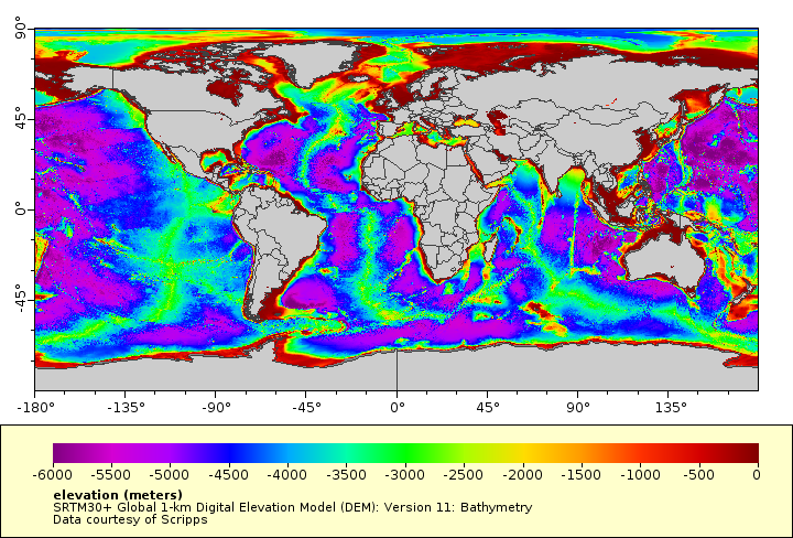
SRTM30+ Global 1-km Digital Elevation Model (DEM): Version 11: Bathymetry
Global 1-km resolution bathymetry from the 30 arc-second SRTM30+ gridded digital elevation model (DEM). Based on the Smith and Sandwell global 1 arc-minute grid between latitudes +/- 81 degrees. Higher resolution grids have been added from the LDEO Ridge Multibeam Synthesis Project, the JAMSTEC Data Site for Research Cruises, and the NOAA/NCEI Coastal Relief Model. Arctic bathymetry is from the International Bathymetric Chart of the Oceans (IBCAO). For a grayscale hillshade image layer of this dataset, see "world_srtm30plus_bathy1km_hillshade" in the distribution links listed in the metadata.
Data and Resources
-
ERDDAP
ERDDAP-GridDAP
This URL provides a viewer and/or data access for this dataset.
-
OPeNDAP
OPeNDAP
THREDDS OPeNDAP
-
OGC-WCS
WCS
Open Geospatial Consortium Web Coverage Service (WCS)
-
OGC-WMS
WMS
Open Geospatial Consortium Web Map Service (WMS)
-
THREDDS Catalog
This URL provides a catalog page for this dataset within THREDDS Data Server...
-
File Information
HTML
This URL provides a standard OPeNDAP html interface for selecting data from...
-
PacIOOS Voyager (Google Maps API)
This URL provides a viewer and/or data access for this dataset.
-
Scripps Institution of Oceanography
HTML
This URL provides a viewer and/or data access for this dataset.
-
Related URL
HTML
This URL provides additional information related to this dataset.
-
Unnamed resource
-
Unnamed resource
-
Unnamed resource
-
THREDDS_NetCDF_Subset
HTML
THREDDS NetCDF Subset Service
-
ISO-19139 (Local) Metadata
The XML content as stored locally by CKAN
-
ISO-19139 (IOOS Registry)
The XML content as published by the IOOS Registry
Graphic Preview
Metadata Date
Metadata Tags
| Online Access |
ERDDAP (DAP Client Access) These data are available for access with an ERDDAP client OPeNDAP (DAP Client Access) These data are available for access with an OPeNDAP client OGC:WCS (OGC Web Coverage Service) These data are available for access with an OGC WCS compatible client OGC:WMS (OGC Web Map Service) These data are available for access with an OGC WMS compatible client
|
| Distribution Formats |
|
| Distributor | Scripps Institution of Oceanography (SIO) |
| Point of Contact |
David T. Sandwell Scripps Institution of Oceanography (SIO) dsandwell@ucsd.edu Online Resource |
| Originator |
David T. Sandwell Scripps Institution of Oceanography (SIO) dsandwell@ucsd.edu Online Resource |
| Originator |
Walter H.F. Smith NOAA Laboratory for Satellite Altimetry Walter.HF.Smith@noaa.gov Online Resource |
| Originator |
Joseph J. Becker Scripps Institution of Oceanography (SIO) |
| Publisher |
Pacific Islands Ocean Observing System (PacIOOS) info@pacioos.org Online Resource |
| Dataset Point of Contact |
Pacific Islands Ocean Observing System (PacIOOS) info@pacioos.org |
| General Documentation |
Related URL
|
| Associated Documentation |
Pacific Islands Ocean Observing System (PacIOOS)
|
| Date(s) |
creation:
2014-11-29
issued: 2015-05-20 revision: 2014-11-29 creation: 2014-11-29 issued: 2015-05-20 revision: 2014-11-29 creation: 2014-11-29 issued: 2015-05-20 revision: 2014-11-29 creation: 2014-11-29 issued: 2015-05-20 revision: 2014-11-29 creation: 2014-11-29 issued: 2015-05-20 revision: 2014-11-29 |
| Purpose | PacIOOS provides timely, reliable, and accurate ocean information to support a safe, clean, productive ocean and resilient coastal zone in the U.S. Pacific Islands region. |
| Use Limitations |
David T. Sandwell, Walter H. F. Smith, and Joseph J. Becker Copyright 2009. The Regents of the University of California. All Rights Reserved. Permission to copy, modify and distribute any part of this gridded bathymetry at 30 second resolution for educational, research and non-profit purposes, without fee, and without a written agreement is hereby granted, provided that the above copyright notice, this paragraph and the following three paragraphs appear in all copies. Those desiring to incorporate this global bathymetry into commercial products or use for commercial purposes should contact the Technology Transfer and Intellectual Property Services, University of California, San Diego, 9500 Gilman Drive, Mail Code 0910, La Jolla, CA 92093-0910, Ph: (858) 534-5815, FAX: (858) 534-7345, E-MAIL:invent@ucsd.edu. IN NO EVENT SHALL THE UNIVERSITY OF CALIFORNIA BE LIABLE TO ANY PARTY FOR DIRECT, INDIRECT, SPECIAL, INCIDENTAL, OR CONSEQUENTIAL DAMAGES, INCLUDING LOST PROFITS, ARISING OUT OF THE USE OF THIS global bathymetry, EVEN IF THE UNIVERSITY OF CALIFORNIA HAS BEEN ADVISED OF THE POSSIBILITY OF SUCH DAMAGE. THE global bathymetry PROVIDED HEREIN IS ON AN 'AS IS' BASIS, AND THE UNIVERSITY OF CALIFORNIA HAS NO OBLIGATION TO PROVIDE MAINTENANCE, SUPPORT, UPDATES, ENHANCEMENTS, OR MODIFICATIONS. THE UNIVERSITY OF CALIFORNIA MAKES NO REPRESENTATIONS AND EXTENDS NO WARRANTIES OF ANY KIND, EITHER IMPLIED OR EXPRESS, INCLUDING, BUT NOT LIMITED TO, THE IMPLIED WARRANTIES OF MERCHANTABILITY OR FITNESS FOR A PARTICULAR PURPOSE, OR THAT THE USE OF THE global bathymetry WILL NOT INFRINGE ANY PATENT, TRADEMARK OR OTHER RIGHTS.
|
| Spatial Bounding Box Coordinates | N: 90.0° S: -90.0° E: 180.0° W: -180.0° |
| Theme keywords |
GCMD Science Keywords
GCMD Platform Keywords
GCMD Instrument Keywords
CF Standard Name Table v39
|
| Data Center keywords |
GCMD Data Center Keywords
|
| Place keywords |
GCMD Location Keywords
|
| Project keywords |
GCMD Project Keywords
|
| Use Constraints |
David T. Sandwell, Walter H. F. Smith, and Joseph J. Becker Copyright 2009. The Regents of the University of California. All Rights Reserved. Permission to copy, modify and distribute any part of this gridded bathymetry at 30 second resolution for educational, research and non-profit purposes, without fee, and without a written agreement is hereby granted, provided that the above copyright notice, this paragraph and the following three paragraphs appear in all copies. Those desiring to incorporate this global bathymetry into commercial products or use for commercial purposes should contact the Technology Transfer and Intellectual Property Services, University of California, San Diego, 9500 Gilman Drive, Mail Code 0910, La Jolla, CA 92093-0910, Ph: (858) 534-5815, FAX: (858) 534-7345, E-MAIL:invent@ucsd.edu. IN NO EVENT SHALL THE UNIVERSITY OF CALIFORNIA BE LIABLE TO ANY PARTY FOR DIRECT, INDIRECT, SPECIAL, INCIDENTAL, OR CONSEQUENTIAL DAMAGES, INCLUDING LOST PROFITS, ARISING OUT OF THE USE OF THIS global bathymetry, EVEN IF THE UNIVERSITY OF CALIFORNIA HAS BEEN ADVISED OF THE POSSIBILITY OF SUCH DAMAGE. THE global bathymetry PROVIDED HEREIN IS ON AN 'AS IS' BASIS, AND THE UNIVERSITY OF CALIFORNIA HAS NO OBLIGATION TO PROVIDE MAINTENANCE, SUPPORT, UPDATES, ENHANCEMENTS, OR MODIFICATIONS. THE UNIVERSITY OF CALIFORNIA MAKES NO REPRESENTATIONS AND EXTENDS NO WARRANTIES OF ANY KIND, EITHER IMPLIED OR EXPRESS, INCLUDING, BUT NOT LIMITED TO, THE IMPLIED WARRANTIES OF MERCHANTABILITY OR FITNESS FOR A PARTICULAR PURPOSE, OR THAT THE USE OF THE global bathymetry WILL NOT INFRINGE ANY PATENT, TRADEMARK OR OTHER RIGHTS.
|
| Lineage Statement | 2015-05-20T00:00:00Z PacIOOS obtained data files from Scripps ftp then masked out the land surface data and converted to NetCDF format. |
| Platforms | |
|---|---|
| Ingestion Attributes | |
| Instrument Attributes | |
| Attribution Information | |
| CF related |