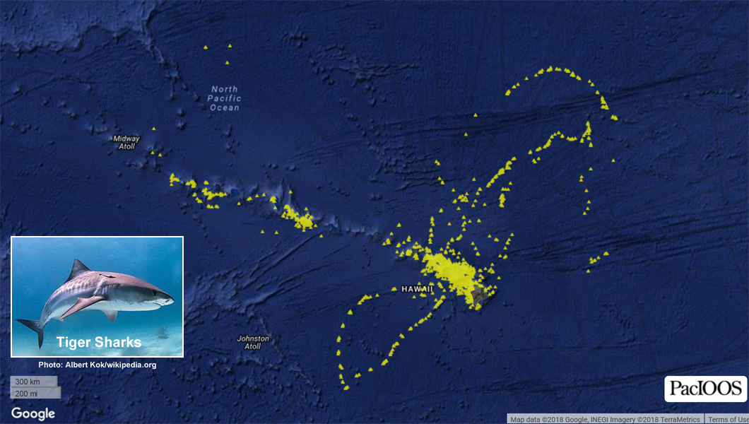
Species Distribution: Tiger Shark - Hawaii
This dataset contains a collection of known point locations of tiger sharks identified via automated satellite tracking of tagged organisms. This can be useful for assessing species abundance, population structure, habitat use, and behavior. This collection is aggregated from multiple tagged organisms and survey periods. Each data point contains attributes for further information about the time and source of the observation. This dataset was compiled by the Pacific Islands Ocean Observing System (PacIOOS) and may be updated in the future if additional data sources are acquired. University of Hawaii's Hawaii Institute of Marine Biology (HIMB) desploys satellite tags on tiger sharks to track their movements within the Main Hawaiian Islands as well as the Papahanaumokuakea Marine National Monument (Northwestern Hawaiian Islands). Top predators play an important role in ecosystems by influencing prey behavior and shaping communities through trophic cascades. NOTE: This GIS layer is restricted to map images only. For all inquiries related to data access, please contact the principal investigators (PIs) directly. For further information, please see: http://www.himb.hawaii.edu/ReefPredator/Tiger%20Shark%20Research.htm
Data and Resources
-
OGC-WMS
WMS
Open Geospatial Consortium Web Map Service (WMS). Supported WMS versions...
-
GeoServer
This URL provides access to this dataset via GeoServer, which offers multiple...
-
GeoExplorer
This URL provides a viewer for this dataset.
-
PacIOOS Voyager (Google Maps API)
This URL provides a viewer and/or data access for this dataset.
-
PacIOOS: Hawaii Tiger Shark Tracking
This URL provides a viewer and/or data access for this dataset.
-
Unnamed resource
-
Unnamed resource
-
OGC-WMS-C
WMS
Open Geospatial Consortium Web Map Service - Cached (WMS-C). Use of WMS-C is...
-
ISO-19139 (Local) Metadata
The XML content as stored locally by CKAN
-
ISO-19139 (IOOS Registry)
The XML content as published by the IOOS Registry
Graphic Preview
Metadata Date
Metadata Tags
| Online Access |
OGC:WMS (OGC Web Map Service) These data are available for access with an OGC WMS compatible client
|
| Distributor | Pacific Islands Ocean Observing System (PacIOOS) |
| Point of Contact |
Pacific Islands Ocean Observing System (PacIOOS) info@pacioos.org Online Resource |
| Originator |
Pacific Islands Ocean Observing System (PacIOOS) info@pacioos.org Online Resource |
| Originator |
Kim N. Holland Hawaii Institue of Marine Biology (HIMB) kholland@hawaii.edu Online Resource |
| Originator |
Carl G. Meyer Hawaii Institue of Marine Biology (HIMB) carlm@hawaii.edu Online Resource |
| Publisher |
Pacific Islands Ocean Observing System (PacIOOS) info@pacioos.org Online Resource |
| Dataset Point of Contact |
Pacific Islands Ocean Observing System (PacIOOS) info@pacioos.org |
| General Documentation | |
| Associated Documentation |
Pacific Islands Ocean Observing System (PacIOOS)
|
| Date(s) |
creation:
2018-01-31
issued: 2018-01-31 revision: 2020-07-13 creation: 2018-01-31 issued: 2018-01-31 revision: 2020-07-13 creation: 2018-01-31 issued: 2018-01-31 revision: 2020-07-13 |
| Purpose | PacIOOS provides timely, reliable, and accurate ocean information to support a safe, clean, productive ocean and resilient coastal zone in the U.S. Pacific Islands region. |
| Use Limitations |
The data may be used and redistributed for free but is not intended for legal use, since it may contain inaccuracies. Neither the data Contributor, University of Hawaii, PacIOOS, NOAA, State of Hawaii nor the United States Government, nor any of their employees or contractors, makes any warranty, express or implied, including warranties of merchantability and fitness for a particular purpose, or assumes any legal liability for the accuracy, completeness, or usefulness, of this information.
|
| Spatial Bounding Box Coordinates | N: 33.408° S: 13.6315° E: -146.933° W: -175.757° |
| Theme keywords |
GCMD Science Keywords
|
| Data Center keywords |
GCMD Data Center Keywords
|
| Place keywords |
GCMD Location Keywords
|
| Project keywords |
GCMD Project Keywords
|
| Use Constraints |
The data may be used and redistributed for free but is not intended for legal use, since it may contain inaccuracies. Neither the data Contributor, University of Hawaii, PacIOOS, NOAA, State of Hawaii nor the United States Government, nor any of their employees or contractors, makes any warranty, express or implied, including warranties of merchantability and fitness for a particular purpose, or assumes any legal liability for the accuracy, completeness, or usefulness, of this information.
|
| Lineage Statement | OGC web services (WMS) enabled by PacIOOS via GeoServer. Original data from source provider may have been reformatted, reprojected, or adjusted in other ways to optimize these capabilities. |
| Platforms | |
|---|---|
| Ingestion Attributes | |
| Instrument Attributes | |
| Attribution Information | |
| CF related |