Papahanaumokuakea Marine National Monument (PMNM) - Northwestern Hawaiian Islands (NWHI)
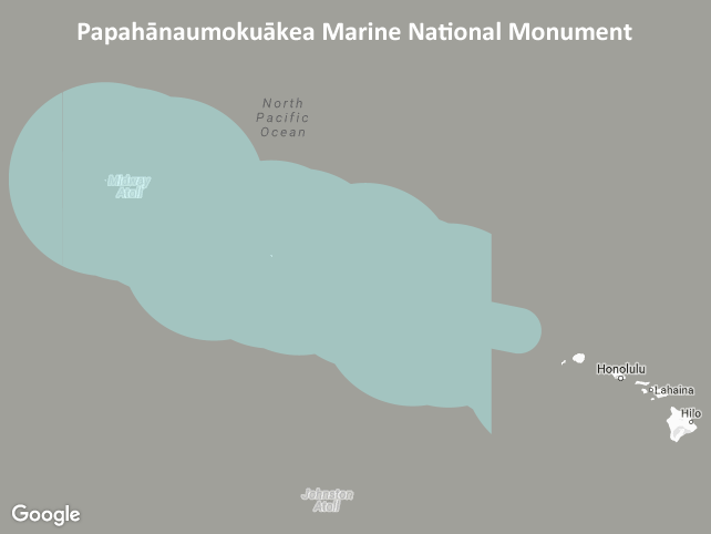
Boundary of the Papahanaumokuakea Marine National Monument (PMNM), located in the Northwestern Hawaiian Islands (NWHI). Created in 2006, Papahanaumokuakea is the largest conservation area in the U.S. and one of the largest marine conservation areas in the world. It is home to extensive coral reefs harboring over 7,000 marine species, one quarter of which are found only in Hawaii. Many of the islands and shallow water environments are important habitats for rare species such as the threatened green sea turtle and the endangered Hawaiian monk seal. Significant cultural Native Hawaiian sites can also be found on the islands of Nihoa and Mokumanamana (Necker Island). Co-managed with the State of Hawaii and the U.S. Department of the Interior, the monument preserves one of the most untouched areas of coral reef in the world. This layer shows the PMNM boundary after its expansion in 2016. On August 26, 2016, President Obama signed a proclamation expanding the monument from 139,797 square miles (362,073 square kilometers) to 582,578 square miles (1,508,870 square kilometers). This extended the monument boundary westward of -163 degrees longitude out to Hawaii's Exclusive Economic Zone (EEZ) at 200 nautical miles offshore. The present layer shows the monument boundary as it existed *after* this expansion. To view the previous, smaller boundary, access the data layer for "hi_noaa_nwhi_papahanaumokuakea_2006" instead. NOTE: This layer is provided as polygon features. For polyline features, please see the layer named "hi_noaa_nwhi_papahanaumokuakea_line" instead. Both polygon and polyline formats are provided for this dataset because the monument boundary spans the antimeridian (+/-180 degrees longitude) making it difficult to display in many GIS software applications without showing a division at the antimeridian.
Data and Resources
-
OGC-WFS
WFS
Open Geospatial Consortium Web Feature Service (WFS). Supported WFS versions...
-
OGC-WMS
WMS
Open Geospatial Consortium Web Map Service (WMS). Supported WMS versions...
-
GeoServer
This URL provides access to this dataset via GeoServer, which offers multiple...
-
GeoExplorer
This URL provides a viewer for this dataset.
-
PacIOOS Voyager (Google Maps API)
This URL provides a viewer and/or data access for this dataset.
-
Related URL
HTML
Papahanaumokuakea Marine National Monument (PMNM). 2016. Papahanaumokuakea...
-
Related URL
HTML
Papahanaumokuakea Marine National Monument (PMNM). 2016. Papahanaumokuakea...
-
Unnamed resource
-
Unnamed resource
-
OGC-WMS-C
WMS
Open Geospatial Consortium Web Map Service - Cached (WMS-C). Use of WMS-C is...
-
ISO-19139 (Local) Metadata
The XML content as stored locally by CKAN
-
ISO-19139 (IOOS Registry)
The XML content as published by the IOOS Registry
Graphic Preview
Metadata Date
Metadata Tags
| Online Access |
OGC:WFS (OGC Web Feature Service) These data are available for access with an OGC WFS compatible client OGC:WMS (OGC Web Map Service) These data are available for access with an OGC WMS compatible client
|
| Distributor | Papahanaumokuakea Marine National Monument (PMNM) |
| Point of Contact |
Papahanaumokuakea Marine National Monument (PMNM) hawaiireef@noaa.gov Online Resource |
| Originator |
Papahanaumokuakea Marine National Monument (PMNM) hawaiireef@noaa.gov Online Resource |
| Publisher |
Pacific Islands Ocean Observing System (PacIOOS) info@pacioos.org Online Resource |
| Dataset Point of Contact |
Pacific Islands Ocean Observing System (PacIOOS) info@pacioos.org |
| General Documentation |
Related URL
Related URL
|
| Associated Documentation |
Pacific Islands Ocean Observing System (PacIOOS)
|
| Date(s) |
creation:
2016-01-25
issued: 2016-01-25 revision: 2016-01-25 creation: 2016-01-25 issued: 2016-01-25 revision: 2016-01-25 creation: 2016-01-25 issued: 2016-01-25 revision: 2016-01-25 creation: 2016-01-25 issued: 2016-01-25 revision: 2016-01-25 |
| Purpose | PacIOOS provides timely, reliable, and accurate ocean information to support a safe, clean, productive ocean and resilient coastal zone in the U.S. Pacific Islands region. |
| Use Limitations |
The data may be used and redistributed for free but is not intended for legal use, since it may contain inaccuracies. Neither the data Contributor, University of Hawaii, PacIOOS, NOAA, State of Hawaii nor the United States Government, nor any of their employees or contractors, makes any warranty, express or implied, including warranties of merchantability and fitness for a particular purpose, or assumes any legal liability for the accuracy, completeness, or usefulness, of this information.
|
| Spatial Bounding Box Coordinates | N: 31.7978661712° S: 19.2345708955462° E: 179.9998389726° W: -179.9999999577° |
| Theme keywords |
GCMD Science Keywords
|
| Data Center keywords |
GCMD Data Center Keywords
|
| Place keywords |
GCMD Location Keywords
|
| Project keywords |
GCMD Project Keywords
|
| Use Constraints |
The data may be used and redistributed for free but is not intended for legal use, since it may contain inaccuracies. Neither the data Contributor, University of Hawaii, PacIOOS, NOAA, State of Hawaii nor the United States Government, nor any of their employees or contractors, makes any warranty, express or implied, including warranties of merchantability and fitness for a particular purpose, or assumes any legal liability for the accuracy, completeness, or usefulness, of this information.
|
| Lineage Statement | 2016-01-25T00:00:00Z OGC web services (WMS and WFS) enabled by PacIOOS via GeoServer. Original data from source provider may have been reformatted, reprojected, or adjusted in other ways to optimize these capabilities. |
| Platforms | |
|---|---|
| Ingestion Attributes | |
| Instrument Attributes | |
| Attribution Information | |
| CF related |