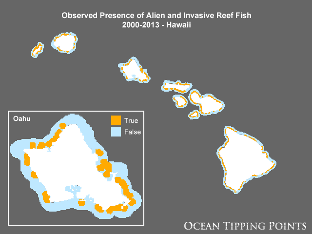
Observed Presence of Alien and Invasive Reef Fish, 2000-2013 - Hawaii
This raster data layer represents the presence of alien and invasive reef fish species within 2 km of an observation, including roi or bluespotted grouper (Cephalopholis argus), ta'ape or bluestripe snapper (Lutjanus kasmira), and to'au or blacktail snapper (Lutjanus fulvus). Original data were queried from the University of Hawaii at Manoa (UH) Fisheries Ecology Research Laboratory (FERL) Hawaii Fish and Benthic Biological Synthesis Database (2000-2013), which is synthesized from NOAA, State of Hawaii Division of Aquatic Resources (DAR), Coral Reef Assessment and Monitoring Program (CRAMP), The Nature Conservancy (TNC), and other surveys conducted across the Main Hawaiian Islands. These data should be considered presence only. Areas with no presence may be due to lack of survey data or observed absence. Raster values of 1 represent areas within 2 km of positive invasive fish observations while values of 0 represent the remaining area. The cell size is 500 m and the area of interest is from the shoreline of the Main Hawaiian Islands extending 5 km offshore and 1 km inshore.
Data and Resources
-
OGC-WCS
WCS
Open Geospatial Consortium Web Coverage Service (WCS). Supported WCS versions...
-
OGC-WMS
WMS
Open Geospatial Consortium Web Map Service (WMS). Supported WMS versions...
-
GeoServer
This URL provides access to this dataset via GeoServer, including multiple...
-
GeoExplorer
This URL provides a viewer for this dataset.
-
PacIOOS Ocean Tipping Points (OTP) Data Viewer
This URL provides a viewer and/or data access for this dataset.
-
Unnamed resource
-
Unnamed resource
HTML
-
Unnamed resource
-
Unnamed resource
-
OGC-WMS-C
WMS
Open Geospatial Consortium Web Map Service - Cached (WMS-C). Use of WMS-C is...
-
ISO-19139 (Local) Metadata
The XML content as stored locally by CKAN
-
ISO-19139 (IOOS Registry)
The XML content as published by the IOOS Registry
Graphic Preview
Metadata Date
Metadata Tags
| Online Access |
OGC:WCS (OGC Web Coverage Service) These data are available for access with an OGC WCS compatible client OGC:WMS (OGC Web Map Service) These data are available for access with an OGC WMS compatible client
|
| Distributor | National Center for Ecological Analysis and Synthesis (NCEAS) |
| Point of Contact |
Carrie V. Kappel National Center for Ecological Analysis and Synthesis (NCEAS) kappel@nceas.ucsb.edu Online Resource |
| Principal Investigator |
Carrie V. Kappel National Center for Ecological Analysis and Synthesis (NCEAS) kappel@nceas.ucsb.edu Online Resource |
| Originator |
Lisa M. Wedding University of Oxford lisa.wedding@ouce.ox.ac.uk Online Resource |
| Originator |
Joey Lecky NOAA Pacific Islands Fisheries Science Center (PIFSC) joey.lecky@noaa.gov |
| Resource Provider |
Ocean Tipping Points (OTP) info@oceantippingpoints.org Online Resource |
| Publisher |
Pacific Islands Ocean Observing System (PacIOOS) info@pacioos.org Online Resource |
| Dataset Point of Contact |
Pacific Islands Ocean Observing System (PacIOOS) info@pacioos.org |
| General Documentation | |
| Associated Documentation |
Pacific Islands Ocean Observing System (PacIOOS)
|
| Resource Provider |
Ocean Tipping Points (OTP) |
| Date(s) |
creation:
2017-03-14
issued: 2017-03-14 revision: 2017-03-14 creation: 2017-03-14 issued: 2017-03-14 revision: 2017-03-14 creation: 2017-03-14 issued: 2017-03-14 revision: 2017-03-14 creation: 2017-03-14 issued: 2017-03-14 revision: 2017-03-14 |
| Purpose | This layer was developed as part of a geospatial database of key anthropogenic pressures to coastal waters of the Main Hawaiian Islands for the Ocean Tipping Points (OTP) project (http://oceantippingpoints.org). Ocean tipping points occur when shifts in human use or environmental conditions result in large, and sometimes abrupt, impacts to marine ecosystems. The ability to predict and understand ocean tipping points can enhance ecosystem management, including critical coral reef management and policies to protect ecosystem services produced by coral reefs. The goal of the Ocean Tipping Points Hawaii case study was to gather, process, and map spatial information on environmental and human-based drivers of coral reef ecosystem conditions. |
| Use Limitations |
Please contact the Ocean Tipping Points (OTP) project in advance of applying these data to project work so that the principal investigator, Carrie Kappel (kappel@nceas.ucsb.edu), can track and communicate data uses and ensure no duplicate efforts are underway. The data may be used and redistributed for free but is not intended for legal use, since it may contain inaccuracies. Neither the data Contributor, University of Hawaii, PacIOOS, NOAA, State of Hawaii nor the United States Government, nor any of their employees or contractors, makes any warranty, express or implied, including warranties of merchantability and fitness for a particular purpose, or assumes any legal liability for the accuracy, completeness, or usefulness, of this information.
|
| Spatial Bounding Box Coordinates | N: 22.279165038591735° S: 18.848641438674104° E: -154.6776891450537° W: -160.2994125718418° |
| Theme keywords |
GCMD Science Keywords
|
| Data Center keywords |
GCMD Data Center Keywords
|
| Place keywords |
GCMD Location Keywords
|
| Project keywords |
GCMD Project Keywords
|
| Use Constraints |
Please contact the Ocean Tipping Points (OTP) project in advance of applying these data to project work so that the principal investigator, Carrie Kappel (kappel@nceas.ucsb.edu), can track and communicate data uses and ensure no duplicate efforts are underway. The data may be used and redistributed for free but is not intended for legal use, since it may contain inaccuracies. Neither the data Contributor, University of Hawaii, PacIOOS, NOAA, State of Hawaii nor the United States Government, nor any of their employees or contractors, makes any warranty, express or implied, including warranties of merchantability and fitness for a particular purpose, or assumes any legal liability for the accuracy, completeness, or usefulness, of this information.
|
| Lineage Statement | 2017-03-14T00:00:00Z OGC web services (WMS and WFS) enabled by PacIOOS via GeoServer. Original data from source provider may have been reformatted, reprojected, or adjusted in other ways to optimize these capabilities. |
| Platforms | |
|---|---|
| Ingestion Attributes | |
| Instrument Attributes | |
| Attribution Information | |
| CF related |