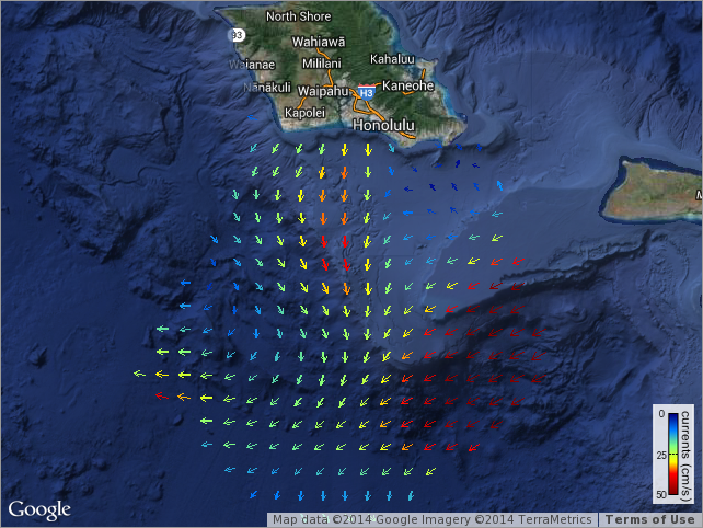
Near-Real Time Surface Ocean Velocity, Hawaii, 1 km Resolution
Surface ocean velocities estimated from HF-Radar (HFR) are representative of the upper 0.3 - 2.5 meters of the ocean. The main objective of near-real time processing is to produce the best product from available data at the time of processing. Radial velocity measurements are obtained from individual radar sites through the U.S. HF-Radar Network. Hourly radial data are processed by unweighted least-squares on a 1 km resolution grid of Hawaii to produce near real-time surface current maps.
Data and Resources
-
OPeNDAP
OPeNDAP
THREDDS OPeNDAP
-
OGC-WCS
WCS
Open Geospatial Consortium Web Coverage Service (WCS)
-
OGC-WMS
WMS
Open Geospatial Consortium Web Map Service (WMS)
-
THREDDS Catalog
This URL provides a catalog page for this dataset within THREDDS Data Server...
-
File Information
HTML
This URL provides a standard OPeNDAP html interface for selecting data from...
-
PacIOOS Voyager (Google Maps API)
This URL provides a viewer for this dataset.
-
PacIOOS website
This URL provides a viewer for this dataset.
-
HFRNet Surface Current Mapping
This URL provides a viewer for this dataset.
-
Unnamed resource
-
Unnamed resource
-
Unnamed resource
-
Unnamed resource
-
THREDDS_NetCDF_Subset
HTML
THREDDS NetCDF Subset Service
-
ISO-19139 (Local) Metadata
The XML content as stored locally by CKAN
-
ISO-19139 (IOOS Registry)
The XML content as published by the IOOS Registry
Graphic Preview
Metadata Date
Metadata Tags
| Online Access |
OPeNDAP (DAP Client Access) These data are available for access with an OPeNDAP client OGC:WCS (OGC Web Coverage Service) These data are available for access with an OGC WCS compatible client OGC:WMS (OGC Web Map Service) These data are available for access with an OGC WMS compatible client
|
| Distribution Formats |
|
| Distributor | U.S. Integrated Ocean Observing System (IOOS) High Frequency Radar Network (HFRNet) |
| Point of Contact |
U.S. Integrated Ocean Observing System (IOOS) High Frequency Radar Network (HFRNet) hfrnet.administrators@sio.ucsd.edu Online Resource |
| Originator |
U.S. Integrated Ocean Observing System (IOOS) High Frequency Radar Network (HFRNet) hfrnet.administrators@sio.ucsd.edu Online Resource |
| Originator |
Pierre Flament University of Hawaii at Manoa pflament@hawaii.edu Online Resource |
| Resource Provider |
Pacific Islands Ocean Observing System (PacIOOS) info@pacioos.org Online Resource |
| Publisher |
Coastal Observing Research and Development Center (CORDC) hfrnet.administrators@sio.ucsd.edu Online Resource |
| Dataset Point of Contact |
U.S. Integrated Ocean Observing System (IOOS) High Frequency Radar Network (HFRNet) hfrnet.administrators@sio.ucsd.edu |
| General Documentation | |
| Associated Documentation |
| Resource Provider |
Pacific Islands Ocean Observing System (PacIOOS) |
| Date(s) |
creation:
2012-01-01
issued: 2012-01-01 revision: 2020-06-16 creation: 2012-01-01 issued: 2012-01-01 revision: 2020-06-16 creation: 2012-01-01 issued: 2012-01-01 revision: 2020-06-16 creation: 2012-01-01 issued: 2012-01-01 revision: 2020-06-16 creation: 2012-01-01 issued: 2012-01-01 revision: 2020-06-16 |
| Use Limitations |
| Time Period | 2012-01-01T00:00:00Z to now |
| Spatial Bounding Box Coordinates | N: 24.916879653930664° S: 16.220399856567383° E: -151.9564971923828° W: -163.14439392089844° |
| Theme keywords |
GCMD Science Keywords
GCMD Platform Keywords
GCMD Instrument Keywords
CF Standard Name Table v39
|
| Data Center keywords |
GCMD Data Center Keywords
|
| Place keywords |
GCMD Location Keywords
|
| Project keywords |
GCMD Project Keywords
|
| Lineage Statement | 2009-07-08T00:00:00Z UH/SOEST (P. Flament) deployed HFR array at Koko Head, Oahu (KOK): 21.2608, -157.7028. 2009-12-11T00:00:00Z UH/SOEST (P. Flament) deployed HFR array at Kakaako (Waikiki), Oahu (KAK): 21.2918, -157.8631. 2010-07-28T22:00:00Z IOOS HFRNet (CORDC/UCSD) begins generating Hawaii surface currents from radial velocities. 2010-09-08T06:45:00Z UH/SOEST (P. Flament) deployed HFR array at Kalaeloa (Barbers Point), Oahu (KAL): 21.2975, -158.0836. 2013-03-26T22:30:00Z UH/SOEST (P. Flament) deployed HFR array at Kaena Point, Oahu (KNA): 21.5749, -158.2819. 2013-12-17T06:40:00Z UH/SOEST (P. Flament) deployed HFR array at Keaukaha, Hawaii Island (KKH): 19.7320, -155.0480. 2015-05-05T07:00:00Z UH/SOEST (P. Flament) deployed HFR array at Pepeekeo, Hawaii Island (PPK): 19.8472, -155.0828. 2015-09-14T19:00:00Z UH/SOEST (P. Flament) deployed HFR array at Kapolei, Oahu (KAP): 21.3114, -158.1169. 2020-06-16T00:00:00Z Exclude invalid Kaena Point, Oahu (KNA) data prior to 2019-11-30T16:00:00Z. 2021-04-19T06:19:00Z To comply with new ITU rules and frequency allocations, changed KAK range resolution from 600 m to 750 m (250 kHz to 200 kHz) and PPK from 666 m to 750 m (224 kHz to 200 kHz). Changed KAL, KOK, and KNA frequency to 16.150 MHz with 100 kHz bandwidth (1.5 km), which does not impact their range or resolution. |
| Platforms | |
|---|---|
| Ingestion Attributes | |
| Instrument Attributes | |
| Attribution Information | |
| CF related |