Mean Higher High Water (MHHW) Sea Level: Honolulu, Hawaii
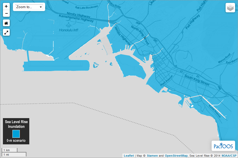
The single value tidal water surface of mean higher high water (MHHW) modeled at the Honolulu tide gauge is used to represent present-day sea level for the urban corridor stretching from Honolulu International Airport to Waikiki and Diamond Head along the south shore of Oahu in the state of Hawaii. Water levels are shown as they would appear during the highest high tides (excluding wind-driven tides). Land elevation was derived using a National Geospatial Agency (NGA)-provided digital elevation model (DEM) based on LiDAR data of the Honolulu area collected in 2009. This "bare earth" DEM (vegetation and structures removed) was used to represent the current topography of the study area above zero elevation. The accuracy of the DEM was validated using a selection of 16 Tidal Benchmarks located within the study area. Data produced in 2014 by Dr. Charles "Chip" Fletcher of the department of Geology & Geophysics (G&G) in the School of Ocean and Earth Science and Technology (SOEST) of the University of Hawaii at Manoa. Supported in part by the NOAA Coastal Storms Program (CSP) and the University of Hawaii Sea Grant College Program. These data should be used strictly as a planning reference and not for navigation, permitting, or other legal purposes.
Data and Resources
-
OGC-WFS
WFS
Open Geospatial Consortium Web Feature Service (WFS). Supported WFS versions...
-
OGC-WMS
WMS
Open Geospatial Consortium Web Map Service (WMS). Supported WMS versions...
-
GeoServer
This URL provides access to this dataset via GeoServer, which offers multiple...
-
GeoExplorer
This URL provides a viewer for this dataset.
-
Unnamed resource
-
Unnamed resource
-
Unnamed resource
-
ISO-19139 (Local) Metadata
The XML content as stored locally by CKAN
-
ISO-19139 (IOOS Registry)
The XML content as published by the IOOS Registry
Graphic Preview
Metadata Date
Metadata Tags
| Online Access |
OGC:WFS (OGC Web Feature Service) These data are available for access with an OGC WFS compatible client OGC:WMS (OGC Web Map Service) These data are available for access with an OGC WMS compatible client
|
| Distributor | University of Hawaii at Manoa |
| Point of Contact |
Charles H. Fletcher University of Hawaii at Manoa fletcher@soest.hawaii.edu Online Resource |
| Originator |
Charles H. Fletcher University of Hawaii at Manoa fletcher@soest.hawaii.edu Online Resource |
| Resource Provider |
University of Hawaii Sea Grant College Program (UHSG) uhsgcomm@hawaii.edu Online Resource |
| Publisher |
Pacific Islands Ocean Observing System (PacIOOS) info@pacioos.org Online Resource |
| Dataset Point of Contact |
Pacific Islands Ocean Observing System (PacIOOS) info@pacioos.org |
| General Documentation | |
| Associated Documentation |
Pacific Islands Ocean Observing System (PacIOOS)
|
| Resource Provider |
University of Hawaii Sea Grant College Program (UHSG) |
| Date(s) |
creation:
2014-09-26
issued: 2014-09-26 revision: 2014-09-26 creation: 2014-09-26 issued: 2014-09-26 revision: 2014-09-26 creation: 2014-09-26 issued: 2014-09-26 revision: 2014-09-26 |
| Purpose | PacIOOS provides timely, reliable, and accurate ocean information to support a safe, clean, productive ocean and resilient coastal zone in the U.S. Pacific Islands region. |
| Use Limitations |
The data may be used and redistributed for free but is not intended for legal use, since it may contain inaccuracies. Neither the data Contributor, University of Hawaii, PacIOOS, NOAA, State of Hawaii nor the United States Government, nor any of their employees or contractors, makes any warranty, express or implied, including warranties of merchantability and fitness for a particular purpose, or assumes any legal liability for the accuracy, completeness, or usefulness, of this information.
|
| Spatial Bounding Box Coordinates | N: 21.358419418335° S: 21.2548732757568° E: -157.782455444336° W: -157.968643188477° |
| Theme keywords |
GCMD Science Keywords
|
| Data Center keywords |
GCMD Data Center Keywords
|
| Place keywords |
GCMD Location Keywords
|
| Project keywords |
GCMD Project Keywords
|
| Use Constraints |
The data may be used and redistributed for free but is not intended for legal use, since it may contain inaccuracies. Neither the data Contributor, University of Hawaii, PacIOOS, NOAA, State of Hawaii nor the United States Government, nor any of their employees or contractors, makes any warranty, express or implied, including warranties of merchantability and fitness for a particular purpose, or assumes any legal liability for the accuracy, completeness, or usefulness, of this information.
|
| Lineage Statement | 2014-09-26T00:00:00Z OGC web services (WMS and WFS) enabled by PacIOOS via GeoServer. Original data from source provider may have been reformatted, reprojected, or adjusted in other ways to optimize these capabilities. |
| Platforms | |
|---|---|
| Ingestion Attributes | |
| Instrument Attributes | |
| Attribution Information | |
| CF related |