Marine Life Conservation Districts - Hawaii
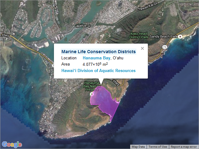
First introduced to Hawaii in 1967 with Hanauama Bay on Oahu, Marine Life Conservation Districts (MLCD) are designed to conserve and replenish marine resources. MLCDs allow only limited fishing and other consumptive uses, or prohibit such uses entirely. They provide fish and other aquatic life with a protected area in which to grow and reproduce, and are home to a great variety of species. MLCDs are established by the State of Hawaii Department of Land and Natural Resources (DLNR), as authorized by Chapter 190 of the Hawaii Revised Statutes. Suggestions for areas to be included in the MLCD system may come from the State Legislature or the general public. In addition, the DLNR's Division of Aquatic Resources (DAR) regularly conducts surveys of marine ecosystems throughout the state, and may recommend MLCD status for areas. For further information, please see: http://dlnr.hawaii.gov/dar/marine-managed-areas/hawaii-marine-life-conservation-districts/
Data and Resources
-
OGC-WFS
WFS
Open Geospatial Consortium Web Feature Service (WFS). Supported WFS versions...
-
OGC-WMS
WMS
Open Geospatial Consortium Web Map Service (WMS). Supported WMS versions...
-
GeoServer
This URL provides access to this dataset via GeoServer, which offers multiple...
-
GeoExplorer
This URL provides a viewer for this dataset.
-
PacIOOS Voyager (Google Maps API)
This URL provides a viewer and/or data access for this dataset.
-
Related URL
This URL provides additional information related to this dataset.
-
Unnamed resource
-
Unnamed resource
-
OGC-WMS-C
WMS
Open Geospatial Consortium Web Map Service - Cached (WMS-C). Use of WMS-C is...
-
ISO-19139 (Local) Metadata
The XML content as stored locally by CKAN
-
ISO-19139 (IOOS Registry)
The XML content as published by the IOOS Registry
Graphic Preview
Metadata Date
Metadata Tags
| Online Access |
OGC:WFS (OGC Web Feature Service) These data are available for access with an OGC WFS compatible client OGC:WMS (OGC Web Map Service) These data are available for access with an OGC WMS compatible client
|
| Distributor | Hawaii Statewide GIS Program |
| Point of Contact |
Hawaii Statewide GIS Program gis@hawaii.gov Online Resource |
| Resource Provider |
Hawaii Statewide GIS Program gis@hawaii.gov Online Resource |
| Publisher |
Pacific Islands Ocean Observing System (PacIOOS) info@pacioos.org Online Resource |
| Dataset Point of Contact |
Pacific Islands Ocean Observing System (PacIOOS) info@pacioos.org |
| General Documentation |
Related URL
|
| Associated Documentation |
Pacific Islands Ocean Observing System (PacIOOS)
|
| Resource Provider |
Hawaii Statewide GIS Program |
| Date(s) |
creation:
2016-01-25
issued: 2016-01-25 revision: 2016-01-25 creation: 2016-01-25 issued: 2016-01-25 revision: 2016-01-25 creation: 2016-01-25 issued: 2016-01-25 revision: 2016-01-25 creation: 2016-01-25 issued: 2016-01-25 revision: 2016-01-25 |
| Purpose | PacIOOS provides timely, reliable, and accurate ocean information to support a safe, clean, productive ocean and resilient coastal zone in the U.S. Pacific Islands region. |
| Use Limitations |
The data may be used and redistributed for free but is not intended for legal use, since it may contain inaccuracies. Neither the data Contributor, University of Hawaii, PacIOOS, NOAA, State of Hawaii nor the United States Government, nor any of their employees or contractors, makes any warranty, express or implied, including warranties of merchantability and fitness for a particular purpose, or assumes any legal liability for the accuracy, completeness, or usefulness, of this information.
|
| Spatial Bounding Box Coordinates | N: 21.6548199994° S: 19.4702963218° E: -154.816699971° W: -158.0702831° |
| Theme keywords |
GCMD Science Keywords
|
| Data Center keywords |
GCMD Data Center Keywords
|
| Place keywords |
GCMD Location Keywords
|
| Project keywords |
GCMD Project Keywords
|
| Use Constraints |
The data may be used and redistributed for free but is not intended for legal use, since it may contain inaccuracies. Neither the data Contributor, University of Hawaii, PacIOOS, NOAA, State of Hawaii nor the United States Government, nor any of their employees or contractors, makes any warranty, express or implied, including warranties of merchantability and fitness for a particular purpose, or assumes any legal liability for the accuracy, completeness, or usefulness, of this information.
|
| Lineage Statement | 2016-01-25T00:00:00Z OGC web services (WMS and WFS) enabled by PacIOOS via GeoServer. Original data from source provider may have been reformatted, reprojected, or adjusted in other ways to optimize these capabilities. |
| Platforms | |
|---|---|
| Ingestion Attributes | |
| Instrument Attributes | |
| Attribution Information | |
| CF related |