Hawaii and Pacific Islands King Tides Project
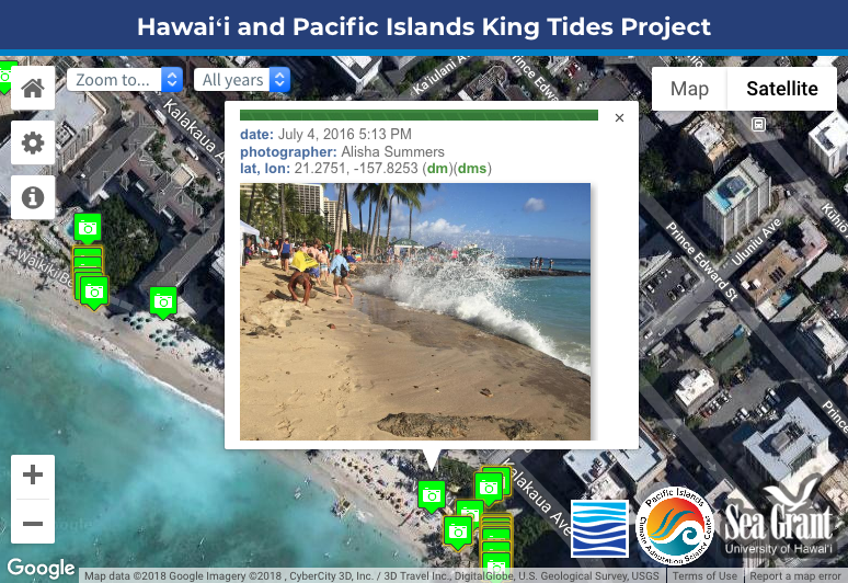
The University of Hawaii Sea Grant College Program's Hawaii and Pacific Islands King Tides Project documents high water level events known as King Tides to better understand future impacts from sea level rise and other coastal hazards. King Tides provide a window into the future because today's high tides are predicted to become tomorrow's average sea levels. Citizen scientists have contributed to this free, publicly-accessible, and crowd-sourced dataset by photographing King Tides at places important to them throughout Hawaii and Oceania. Photos, observations, date, time, location, and other metadata are submitted online. This publicly-accessible online database informs research, policy, and decision making across the State of Hawaii and the wider Pacific region. King tides are the highest astronomical tides of the year. The scientific term for a King Tide is a perigean spring tide. King Tides in the Hawaiian Islands tend to occur during the summer (e.g., July and August) and winter months (e.g., December and January) in conjunction with new moons and full moons. King Tides, or the highest high tides of the year, are a unique coastal hazard. The timing of these extreme water level events can be anticipated through the use of tidal predictions, yet their impacts (e.g., coastal flooding and inundation in low-lying areas) can have devastating consequences for coastal inhabitants, particularly when combined with severe weather or high wave events. It is a common misconception that King Tides are the result of man-made climate change. When in reality, they are not byproducts of climate change, rather they are windows for us to see what the future of sea level rise from global climate change might look like along our coastlines. With future sea level rise we can expect more frequent high tide flooding and monthly and even daily high tides exceeding coastal inundation thresholds. When sharing these photographs, please cite this project with the following attribution: (c) Hawaii Sea Grant King Tides Project, (year of photo). Some rights reserved. Licensed under the Creative Commons Attribution 4.0 International License (CC BY 4.0).
Data and Resources
-
OGC-WFS
WFS
Open Geospatial Consortium Web Feature Service (WFS). Supported WFS versions...
-
OGC-WMS
WMS
Open Geospatial Consortium Web Map Service (WMS). Supported WMS versions...
-
GeoServer
This URL provides access to this dataset via GeoServer, which offers multiple...
-
GeoExplorer
This URL provides a viewer for this dataset.
-
King Tides Map Viewer
HTML
This URL provides a viewer and/or data access for this dataset.
-
King Tides Photo Entry Form
HTML
This URL provides a viewer and/or data access for this dataset.
-
Unnamed resource
-
Unnamed resource
-
Unnamed resource
-
ISO-19139 (Local) Metadata
The XML content as stored locally by CKAN
-
ISO-19139 (IOOS Registry)
The XML content as published by the IOOS Registry
Graphic Preview
Metadata Date
Metadata Tags
| Online Access |
OGC:WFS (OGC Web Feature Service) These data are available for access with an OGC WFS compatible client OGC:WMS (OGC Web Map Service) These data are available for access with an OGC WMS compatible client
|
| Distributor | Hawaii Sea Grant King Tides Project |
| Point of Contact |
Hawaii Sea Grant King Tides Project kingtide@hawaii.edu Online Resource |
| Originator |
Hawaii Sea Grant King Tides Project kingtide@hawaii.edu Online Resource |
| Originator |
Maya Walton University of Hawaii Sea Grant College Program waltonm@hawaii.edu Online Resource |
| Publisher |
Pacific Islands Ocean Observing System (PacIOOS) info@pacioos.org Online Resource |
| Dataset Point of Contact |
Pacific Islands Ocean Observing System (PacIOOS) info@pacioos.org |
| General Documentation | |
| Associated Documentation |
Pacific Islands Ocean Observing System (PacIOOS)
|
| Date(s) |
creation:
2018-12-14
issued: 2018-12-14 revision: 2018-12-14 creation: 2018-12-14 issued: 2018-12-14 revision: 2018-12-14 creation: 2018-12-14 issued: 2018-12-14 revision: 2018-12-14 |
| Purpose | PacIOOS provides timely, reliable, and accurate ocean information to support a safe, clean, productive ocean and resilient coastal zone in the U.S. Pacific Islands region. |
| Use Limitations |
The data may be used and redistributed for free but is not intended for legal use, since it may contain inaccuracies. Neither the data Contributor, University of Hawaii, PacIOOS, NOAA, State of Hawaii nor the United States Government, nor any of their employees or contractors, makes any warranty, express or implied, including warranties of merchantability and fitness for a particular purpose, or assumes any legal liability for the accuracy, completeness, or usefulness, of this information.
|
| Spatial Bounding Box Coordinates | N: 28.218039° S: -14.32367° E: 171.3731519° W: -177.378088° |
| Theme keywords |
GCMD Science Keywords
|
| Data Center keywords |
GCMD Data Center Keywords
|
| Place keywords |
GCMD Location Keywords
|
| Project keywords |
GCMD Project Keywords
|
| Use Constraints |
The data may be used and redistributed for free but is not intended for legal use, since it may contain inaccuracies. Neither the data Contributor, University of Hawaii, PacIOOS, NOAA, State of Hawaii nor the United States Government, nor any of their employees or contractors, makes any warranty, express or implied, including warranties of merchantability and fitness for a particular purpose, or assumes any legal liability for the accuracy, completeness, or usefulness, of this information.
|
| Lineage Statement | 2018-12-14T00:00:00Z OGC web services (WMS and WFS) enabled by PacIOOS via GeoServer. Original data from source provider may have been reformatted, reprojected, or adjusted in other ways to optimize these capabilities. |
| Platforms | |
|---|---|
| Ingestion Attributes | |
| Instrument Attributes | |
| Attribution Information | |
| CF related |