Fish Aggregation Devices (FADs) - Hawaii
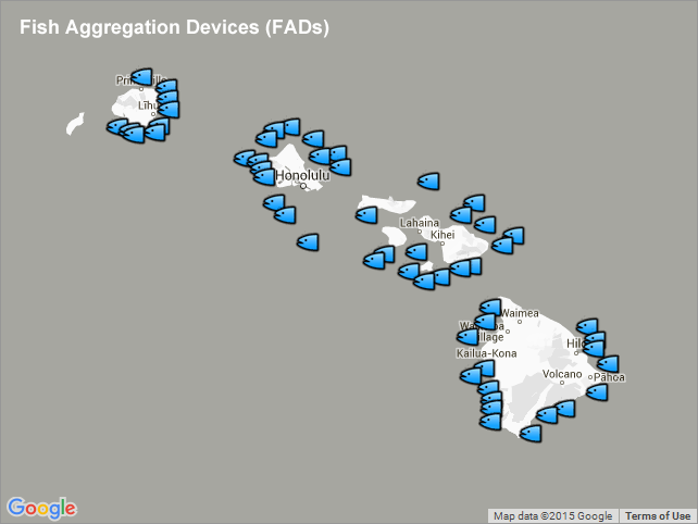
Location of fish aggregation device (FAD) buoys within the Main Hawaiian Islands. Fishermen in Hawaii and other parts of the world have long known that tunas and other pelagic fishes are attracted to floating objects. Fishermen have benefited from this behavior by fishing around floating logs, nets, debris and other flotsam. Hawaii has capitalized on this phenomena by placing FADs in the waters surrounding the Hawaiian Islands. In these waters, schools of tunas and other important pelagic fishes such as dolphin-fish (mahi-mahi), wahoo (ono), and billfishes can be induced to congregate and remain for periods of time in an area so that fishers can easily locate them. Thus, the FADs are used to "attract" and "hold" pelagic fishes in areas to enhance fishing. NOTE: Please do not rely on these buoys to check your position. Most buoys have only been located to the nearest 0.1 minute (6 seconds). In addition, each buoy has a watch circle that can be as much as 1 mile in diameter.
Data and Resources
-
OGC-WFS
WFS
Open Geospatial Consortium Web Feature Service (WFS). Supported WFS versions...
-
OGC-WMS
WMS
Open Geospatial Consortium Web Map Service (WMS). Supported WMS versions...
-
GeoServer
This URL provides access to this dataset via GeoServer, which offers multiple...
-
GeoExplorer
This URL provides a viewer for this dataset.
-
PacIOOS Voyager (Google Maps API)
This URL provides a viewer and/or data access for this dataset.
-
Related URL
State of Hawaii: Fish Aggregation Device (FAD) Program
-
Unnamed resource
-
Unnamed resource
-
Unnamed resource
-
OGC-WMS-C
WMS
Open Geospatial Consortium Web Map Service - Cached (WMS-C). Use of WMS-C is...
-
ISO-19139 (Local) Metadata
The XML content as stored locally by CKAN
-
ISO-19139 (IOOS Registry)
The XML content as published by the IOOS Registry
Graphic Preview
Metadata Date
Metadata Tags
| Online Access |
OGC:WFS (OGC Web Feature Service) These data are available for access with an OGC WFS compatible client OGC:WMS (OGC Web Map Service) These data are available for access with an OGC WMS compatible client
|
| Distributor | State of Hawaii Division of Aquatic Resources (DAR) |
| Point of Contact |
State of Hawaii Division of Aquatic Resources (DAR) DLNR.aquatics@hawaii.gov Online Resource |
| Originator |
State of Hawaii Division of Aquatic Resources (DAR) DLNR.aquatics@hawaii.gov Online Resource |
| Publisher |
Pacific Islands Ocean Observing System (PacIOOS) info@pacioos.org Online Resource |
| Dataset Point of Contact |
Pacific Islands Ocean Observing System (PacIOOS) info@pacioos.org |
| General Documentation |
Related URL
|
| Associated Documentation |
Pacific Islands Ocean Observing System (PacIOOS)
|
| Date(s) |
creation:
2016-01-25
issued: 2016-01-25 revision: 2016-01-25 creation: 2016-01-25 issued: 2016-01-25 revision: 2016-01-25 creation: 2016-01-25 issued: 2016-01-25 revision: 2016-01-25 creation: 2016-01-25 issued: 2016-01-25 revision: 2016-01-25 |
| Purpose | PacIOOS provides timely, reliable, and accurate ocean information to support a safe, clean, productive ocean and resilient coastal zone in the U.S. Pacific Islands region. |
| Use Limitations |
The data may be used and redistributed for free but is not intended for legal use, since it may contain inaccuracies. Neither the data Contributor, University of Hawaii, PacIOOS, NOAA, State of Hawaii nor the United States Government, nor any of their employees or contractors, makes any warranty, express or implied, including warranties of merchantability and fitness for a particular purpose, or assumes any legal liability for the accuracy, completeness, or usefulness, of this information.
|
| Spatial Bounding Box Coordinates | N: 22.33° S: 18.9558333333333° E: -154.778333333333° W: -159.731666666667° |
| Theme keywords |
GCMD Science Keywords
|
| Data Center keywords |
GCMD Data Center Keywords
|
| Place keywords |
GCMD Location Keywords
|
| Project keywords |
GCMD Project Keywords
|
| Use Constraints |
The data may be used and redistributed for free but is not intended for legal use, since it may contain inaccuracies. Neither the data Contributor, University of Hawaii, PacIOOS, NOAA, State of Hawaii nor the United States Government, nor any of their employees or contractors, makes any warranty, express or implied, including warranties of merchantability and fitness for a particular purpose, or assumes any legal liability for the accuracy, completeness, or usefulness, of this information.
|
| Lineage Statement | 2016-01-25T00:00:00Z OGC web services (WMS and WFS) enabled by PacIOOS via GeoServer. Original data from source provider may have been reformatted, reprojected, or adjusted in other ways to optimize these capabilities. |
| Platforms | |
|---|---|
| Ingestion Attributes | |
| Instrument Attributes | |
| Attribution Information | |
| CF related |