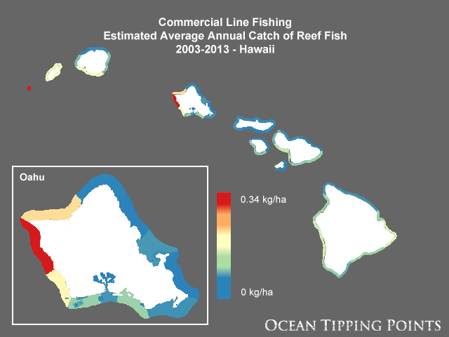
Commercial Line Fishing Estimated Average Annual Catch of Reef Fish, 2003-2013 - Hawaii
Nearshore fisheries in the Main Hawaiian Islands encompass a diverse group of fishers using a wide array of gears and targeting many different species. Communities in Hawaii often rely on these fisheries for economic, social, and cultural services. However, the stress from overfishing can cause ecosystem degradation and long-term economic loss. This layer represents the average annual commercial catch of reef fish by line fishing over the years 2003-2013 as reported in commercial catch data collected by the State of Hawaii Department of Aquatic Resources (DAR) Commercial Marine Landings Database (CML). "Line fishing" is a fairly broad category that can include casting, trolling, hand line, short line, and others. These gears were grouped together for consistency with non-commercial catch estimates from McCoy et al. (2018). Commercial catch is reported to DAR in large irregular reporting blocks by gear and by species. This layer's spatial footprint aligns with the inshore commercial reporting blocks from the shapefile served on the Hawaii Statewide GIS Program website (Fishchart2008.shp) (http://planning.hawaii.gov/gis/download-gis-data/). Data are filtered by DAR before release such that reporting blocks with less than three fishers reporting are excluded in order to protect fisher identities. It is not possible to explicitly distinguish between boat-based and shore-based fishing based on the gear types reported in CML data. The Ocean Tipping Points (OTP) project filtered the data for line fishing and reef fish species only and calculated average annual catch in kilograms by reporting block to match with data from the Marine Recreational Information Program (MRIP). In marine protected areas (MPAs) where boat-based fishing is not allowed, catch was set to zero; and inside de facto MPAs with restricted access, catch was reduced according to expert input and local knowledge. Average annual commercial catch data were converted from polygon to raster and then divided by the number of 100-m raster cells within each reporting block so that units are comparable to non-commercial fishing layers (kg/ha). The result assumes commercial catch is evenly distributed spatially across each reporting block.
Data and Resources
-
OGC-WCS
WCS
Open Geospatial Consortium Web Coverage Service (WCS). Supported WCS versions...
-
OGC-WMS
WMS
Open Geospatial Consortium Web Map Service (WMS). Supported WMS versions...
-
GeoServer
This URL provides access to this dataset via GeoServer, including multiple...
-
GeoExplorer
This URL provides a viewer for this dataset.
-
PacIOOS Ocean Tipping Points (OTP) Data Viewer
This URL provides a viewer and/or data access for this dataset.
-
Unnamed resource
-
Unnamed resource
-
Unnamed resource
-
Unnamed resource
-
OGC-WMS-C
WMS
Open Geospatial Consortium Web Map Service - Cached (WMS-C). Use of WMS-C is...
-
ISO-19139 (Local) Metadata
The XML content as stored locally by CKAN
-
ISO-19139 (IOOS Registry)
The XML content as published by the IOOS Registry
Graphic Preview
Metadata Date
Metadata Tags
| Online Access |
OGC:WCS (OGC Web Coverage Service) These data are available for access with an OGC WCS compatible client OGC:WMS (OGC Web Map Service) These data are available for access with an OGC WMS compatible client
|
| Distributor | National Center for Ecological Analysis and Synthesis (NCEAS) |
| Point of Contact |
Carrie V. Kappel National Center for Ecological Analysis and Synthesis (NCEAS) kappel@nceas.ucsb.edu Online Resource |
| Principal Investigator |
Carrie V. Kappel National Center for Ecological Analysis and Synthesis (NCEAS) kappel@nceas.ucsb.edu Online Resource |
| Originator |
Kimberly A. Selkoe National Center for Ecological Analysis and Synthesis (NCEAS) selkoe@nceas.ucsb.edu Online Resource |
| Resource Provider |
Ocean Tipping Points (OTP) info@oceantippingpoints.org Online Resource |
| Publisher |
Pacific Islands Ocean Observing System (PacIOOS) info@pacioos.org Online Resource |
| Dataset Point of Contact |
Pacific Islands Ocean Observing System (PacIOOS) info@pacioos.org |
| General Documentation | |
| Associated Documentation |
Pacific Islands Ocean Observing System (PacIOOS)
|
| Resource Provider |
Ocean Tipping Points (OTP) |
| Date(s) |
creation:
2017-04-18
issued: 2017-04-18 revision: 2017-04-18 creation: 2017-04-18 issued: 2017-04-18 revision: 2017-04-18 creation: 2017-04-18 issued: 2017-04-18 revision: 2017-04-18 creation: 2017-04-18 issued: 2017-04-18 revision: 2017-04-18 |
| Purpose | This layer was developed as part of a geospatial database of key anthropogenic pressures to coastal waters of the Main Hawaiian Islands for the Ocean Tipping Points (OTP) project (http://oceantippingpoints.org). Ocean tipping points occur when shifts in human use or environmental conditions result in large, and sometimes abrupt, impacts to marine ecosystems. The ability to predict and understand ocean tipping points can enhance ecosystem management, including critical coral reef management and policies to protect ecosystem services produced by coral reefs. The goal of the Ocean Tipping Points Hawaii case study was to gather, process, and map spatial information on environmental and human-based drivers of coral reef ecosystem conditions. |
| Use Limitations |
Please contact the Ocean Tipping Points (OTP) project in advance of applying these data to project work so that the principal investigator, Carrie Kappel (kappel@nceas.ucsb.edu), can track and communicate data uses and ensure no duplicate efforts are underway. The data may be used and redistributed for free but is not intended for legal use, since it may contain inaccuracies. Neither the data Contributor, University of Hawaii, PacIOOS, NOAA, State of Hawaii nor the United States Government, nor any of their employees or contractors, makes any warranty, express or implied, including warranties of merchantability and fitness for a particular purpose, or assumes any legal liability for the accuracy, completeness, or usefulness, of this information.
|
| Spatial Bounding Box Coordinates | N: 22.589967639692087° S: 18.50382548747189° E: -154.24231813047925° W: -160.8274310364662° |
| Theme keywords |
GCMD Science Keywords
|
| Data Center keywords |
GCMD Data Center Keywords
|
| Place keywords |
GCMD Location Keywords
|
| Project keywords |
GCMD Project Keywords
|
| Use Constraints |
Please contact the Ocean Tipping Points (OTP) project in advance of applying these data to project work so that the principal investigator, Carrie Kappel (kappel@nceas.ucsb.edu), can track and communicate data uses and ensure no duplicate efforts are underway. The data may be used and redistributed for free but is not intended for legal use, since it may contain inaccuracies. Neither the data Contributor, University of Hawaii, PacIOOS, NOAA, State of Hawaii nor the United States Government, nor any of their employees or contractors, makes any warranty, express or implied, including warranties of merchantability and fitness for a particular purpose, or assumes any legal liability for the accuracy, completeness, or usefulness, of this information.
|
| Lineage Statement | 2017-04-18T00:00:00Z OGC web services (WMS and WFS) enabled by PacIOOS via GeoServer. Original data from source provider may have been reformatted, reprojected, or adjusted in other ways to optimize these capabilities. |
| Platforms | |
|---|---|
| Ingestion Attributes | |
| Instrument Attributes | |
| Attribution Information | |
| CF related |