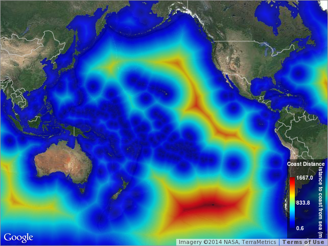
Distance to Nearest Coastline: 0.04-Degree Grid: Ocean
A global data set of ocean distances from the nearest coastline. NASA's Ocean Biology Processing Group (OBPG) generated this data set using the Generic Mapping Tools (GMT) software package. Distances were computed with GMT using its intermediate-resolution coastline and then gridded globally at a spatial resolution of 0.04 degrees.
Data and Resources
-
ERDDAP
ERDDAP-GridDAP
This URL provides a viewer and/or data access for this dataset.
-
OPeNDAP
OPeNDAP
THREDDS OPeNDAP
-
OGC-WCS
WCS
Open Geospatial Consortium Web Coverage Service (WCS)
-
OGC-WMS
WMS
Open Geospatial Consortium Web Map Service (WMS)
-
THREDDS Catalog
This URL provides a catalog page for this dataset within THREDDS Data Server...
-
File Information
HTML
This URL provides a standard OPeNDAP html interface for selecting data from...
-
Related URL
This URL provides additional information related to this dataset.
-
Unnamed resource
-
Unnamed resource
-
THREDDS_NetCDF_Subset
HTML
THREDDS NetCDF Subset Service
-
ISO-19139 (Local) Metadata
The XML content as stored locally by CKAN
-
ISO-19139 (IOOS Registry)
The XML content as published by the IOOS Registry
Graphic Preview
Metadata Date
Metadata Tags
| Online Access |
ERDDAP (DAP Client Access) These data are available for access with an ERDDAP client OPeNDAP (DAP Client Access) These data are available for access with an OPeNDAP client OGC:WCS (OGC Web Coverage Service) These data are available for access with an OGC WCS compatible client OGC:WMS (OGC Web Map Service) These data are available for access with an OGC WMS compatible client
|
| Distribution Formats |
|
| Distributor | NASA Ocean Biology Processing Group (OBPG) |
| Point of Contact |
NASA Ocean Biology Processing Group (OBPG) Online Resource |
| Originator |
NASA Ocean Biology Processing Group (OBPG) Online Resource |
| Originator |
Richard P. Stumpf NOAA National Ocean Service (NOS) richard.stumpf@noaa.gov |
| Publisher |
Pacific Islands Ocean Observing System (PacIOOS) info@pacioos.org Online Resource |
| Dataset Point of Contact |
Pacific Islands Ocean Observing System (PacIOOS) info@pacioos.org |
| General Documentation |
Related URL
|
| Associated Documentation |
Pacific Islands Ocean Observing System (PacIOOS)
|
| Date(s) |
creation:
2012-07-12
issued: 2012-07-12 revision: 2012-07-12 creation: 2012-07-12 issued: 2012-07-12 revision: 2012-07-12 creation: 2012-07-12 issued: 2012-07-12 revision: 2012-07-12 creation: 2012-07-12 issued: 2012-07-12 revision: 2012-07-12 creation: 2012-07-12 issued: 2012-07-12 revision: 2012-07-12 |
| Purpose | PacIOOS provides timely, reliable, and accurate ocean information to support a safe, clean, productive ocean and resilient coastal zone in the U.S. Pacific Islands region. |
| Use Limitations |
The data may be used and redistributed for free but is not intended for legal use, since it may contain inaccuracies. Neither the data Contributor, University of Hawaii, PacIOOS, NOAA, State of Hawaii nor the United States Government, nor any of their employees or contractors, makes any warranty, express or implied, including warranties of merchantability and fitness for a particular purpose, or assumes any legal liability for the accuracy, completeness, or usefulness, of this information.
|
| Time Period | 2009-06-01T00:00:00Z to 2009-06-01T00:00:00Z |
| Spatial Bounding Box Coordinates | N: 89.98° S: -89.98° E: 179.98° W: -179.98° |
| Theme keywords |
GCMD Science Keywords
GCMD Platform Keywords
GCMD Instrument Keywords
CF Standard Name Table v39
|
| Data Center keywords |
GCMD Data Center Keywords
|
| Place keywords |
GCMD Location Keywords
|
| Project keywords |
GCMD Project Keywords
|
| Use Constraints |
The data may be used and redistributed for free but is not intended for legal use, since it may contain inaccuracies. Neither the data Contributor, University of Hawaii, PacIOOS, NOAA, State of Hawaii nor the United States Government, nor any of their employees or contractors, makes any warranty, express or implied, including warranties of merchantability and fitness for a particular purpose, or assumes any legal liability for the accuracy, completeness, or usefulness, of this information.
|
| Lineage Statement | 2012-07-12T00:00:00Z Downloaded XYZ ASCII text from NASA/GSFC and converted to NetCDF (J. Maurer). |
| Platforms | |
|---|---|
| Ingestion Attributes | |
| Instrument Attributes | |
| Attribution Information | |
| CF related |